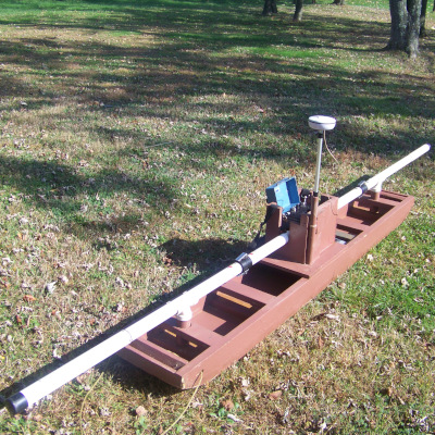
EM-31 MK2 with Mesa Field PC and Geode GPS/Antenna Combo
Price range: $100.00 through $1,575.00
The Geonics EM-31 MK2 maps geologic variations, groundwater contaminants or any other subsurface feature associated with ground conductivity. The EM-31 uses electromagnetic inductive technique that allows measurements without ground contact.
** Sled pictured is no longer available **
Rental Rates: A prep fee will be assessed for this item.
| Daily | Weekly | Monthly |
| $100 | $450 | $1575 |
- Our rental Geonics EM31 comes with an Archer Field PC and hemisphere GPS with external antenna
- Ground conductivity (quad-phase) and magnetic susceptibility (in-phase) measurements are read directly from an integrated DL600 data logger (which can be easily removed from the console for data transfer)
- Real Time (RT) graphical presentation of the data during collection is possible by connecting a computer directly to the RS232 output port on the front panel with an optional RS232 interconnect cable
- Sled is rented separately
- Measured Quantities
- Apparent conductivity in millisiemens per metre (mS/m)
- In-phase ratio of the secondary to primary magnetic field in parts per thousand (ppt)
- Intercoil Spacing:
- 3.66 metres
- Operating Frequency
- 9.8 kHz
- Measuring Range
- Conduct.:10,100,1K mS/m
- In-phase: +/- 20 ppt
- Measurement Resolution
- +/- 0.1% of full scale
- Measurement Accuracy
- +/- 5% at 20 mS/m
- Data Storage
- 10,000 records (2 components)
- 16,500 records (1 component)
- Weight
- 12.4 kg